Saturday, December 31, 2022

Well, there goes another year.........

Where it went, I don't know, but I've managed to have a very enjoyable year on two wheels with no bones broken and not that many punctures to contend with. I've ridden in the cold, in the rain, in strong wind and on the hottest days of the year, and occasionally on those rare perfect days for cycling with fair temperatures and little or no wind. I've tried a couple of new cafes for the mid-ride coffee and cake (always delicious) and have increased my cycling wardrobe possibly beyond what is reasonable for a 61 year old leisure cyclist! And I've enjoyed every minute of it!

Highlights of the year;

1 - The Scotland trip - five fantastic rides through some truly spectacular scenery, especially the last ride over the top from Grantown to Culloden and back via Slochd and Carrbridge. 

2 - Sundown 60 - 60 miles through the stunning Yorkshire Wolds, plenty of climbing ending with fish and chips, beer and a beautiful sunset. I've booked on next year's event already!

3 - Cat & Fiddle Challenge - I finally got to cycle over the Cat & Fiddle, through some lovely scenery. Only the start and end disappointed, riding through the outskirts of Stoke, but not enough to spoil a cracking day out.

Honourable mention - Bangor On Dee - a lovely pub by the side of the river in Bangor On Dee (must stop for a coffee and sandwich next time) and superb vistas of the Dee at the border between England (Farndon) and Wales (Holt).


Goals review

Ride 5200 miles - achieved, on 30th December. To be honest, at the start of December I was only 49 miles short, and if I hadn't reached 5200 it wouldn't have been the end of the earth. I'll never chase miles for the sake of it, otherwise enjoyment will be sacrificed, and if you don't enjoy it what's the point!

Ride a century - didn't do this, but I did two rides of 75 miles, both very enjoyable. Again, I'm not losing any sleep over not riding 100 miles, I'll probably go for it next year though. 

Ride different places - Scotland again, Bangor-On-Dee twice, Cat & Fiddle and the Roaches and several new areas south of Nantwich meant this was achieved. Not driving out to a start point limits where I can go, however next year I'll aim to do a few more far flung rides, plus will look to extend further into Cheshire and Chester. Above all, as with all goals, I will endeavour to keep it FUN and ENJOYABLE!


Monday, May 30, 2022

The Sunday ride after the Saturday ride before

I was woken early the morning after the Sundown 60, by the birds. The smaller birds were quite tuneful, but then the bigger ones joined in with their noisy squabbles. CAAWWWWW!!!! ARRRKKKKKKK!! CRAAAARRRRKKK!!!! And to put the icing on the cake, the pigeons turned up. Woo-Hooooo-Hooo-Hoo-Hoo! Not what you want at four o'clock. Still, it sounded like the wind had died down. I managed to get a bit more napping done, although at one point I was woken by the sound of rain on the tent. I finally got up around half seven, at which point the tent was rattling with the wind (outside, not in!). I went and got washed, then set about taking the tent down. This was fine until I came to fold it up, at which point I decided to put up with a rough fold and sort it at home, given the wind was making it difficult. Finally packed up, I left the brewery and headed to Redcliffe Farm Shop, where I'd made a breakfast reservation. There was only one choice to be had really - I went for the Full English! I'd planned a forty mile ride to Flamborough to make the most of my time back in Scarborough, although the weather and my legs from the previous days ride made me wonder if I was doing the right thing. The breakfast was definitely the right thing though, it was as tasty as it always was. After breakfast, I kitted up, got the bike out of the car and set off. I rode on familiar roads past Lebberston and Killerby, turning left in Cayton where I flew to Folkton with the strong wind behind me. After Folkton though, I knew there would be a stiff test, as the route I'd planned took me to Hunmanby up White Gate Hill. This is just over half a mile long, with an average gradient of nearly 9%, but varies. I managed to get up the hill ok, then enjoyed the long descent down into Hunmanby with the sea stretching out in front of me. Entering Hunmanby I took a right and climbed gently up to the road for the Wold Top brewery. After a short while I turned left to head towards Burton Fleming, which after a short bit of gentle uphill turned into a good downhill for a couple of miles. At Burton Fleming I turned left, heading east towards the coast on an undulating roller coaster of a road. The scenery again was lovely, and the road fairly quiet. The road dog legs through Grindale, and just before entering the small village the road surface was very rough, necessitating a quick trip on the wrong side of the road. After a couple of miles the road joined the A165 Bridlington Scarborough road, and I turned right to head into Brid, going over a new roundabout that is so new it didn't exist on my computer map! Entering Brid, I took the Flamborough road, which went on for far longer than I was expecting, then at Flamborough I took Lighthouse Road to get to the lighthouse (surprise surprise), again travelling much further than I was expecting. Although the forecast was for showers I'd been lucky to this point, and hadn't needed the rain jacket I was wearing, but because of the strong wind I was very glad for it. At the lighthouse I bought an ice cream and sat on a bench overlooking the sea, contemplating the battle I'd have into the wind back to Redcliffe Farm. Thinking doesn't get you anywhere though, so I remounted and set off back. At Flamborough I turned left, heading north west and into the teeth of the wind. As well as fighting the wind, I had seven miles of uphill road to contend with. Fortunately the road undulated a little so there were times when the going was a little easier. Eventually I reached Speeton, after which I turned into Reighton and went through the village, downhill to cross the A165 towards Hunmanby. Even though I was going downhill I was still having to pedal to keep my momentum. Heading into Hunmanby I passed the Piebald Inn, I'd been there before and they do the best pies, lots of different varieties, well worth a visit, but not for me today. I rode through Hunmanby and out towards Muston, where they used to hold an annual scarecrow festival. From Muston I cycled back to the A165 and headed into Filey, where I made my way to St Mary's Roman Catholic church to pay my respects to Margaret, our old neighbour in Scarborough, who has a rose bush planted there in her memory. From there I rode through town and out to pick up the A165 again. I rode along this to the next rounadbout where I spotted a path running alongside the road by the opposite carriageway. At a gap in the oncoming traffic I nipped onto this, feeling much safer now I was off the busy A road. After a while the path turned away and put me out on the road to Blue Dolphin Caravan Park, and from here it was a short stretch to road Redcliffe Farm was on, and I finally rode up to the car slightly tired. All told, it was another good ride, and I missed any showers that may have fallen, so can't really complain.


A ride with beer and fish and chips


I'd been looking forward to this ride for a long while. The Wold Top Sundown 60 sportive, a 60 mile bike ride through the Yorkshire Wolds, starting and finishing at the Wold Top brewery where a free pint and fish and chips awaited. When I lived in Scarborough I used to ride round by the brewery regularly, so it would be nice to reacquaint myself with the old roads. I'd booked camping as well, as I didn't fancy having to drive back home after a long and challenging ride. I'd not been camping in decades, so was kind of looking forward to the adventure. I set off early on the day and had a good journey across the Pennines to pick up the A64 for York, turning off to pick up the A166 through Gate Helmsley and Stamford Bridge. This was a very scenic drive, but gave some hints about the ups and downs that I'd face later on. At one point I spotted some Sportive HQ signs along the way, and knew that was the route I'd be following later. It didn't help when the road went uphill, that was a pleasure to be had later on! I eventually arrived at the brewery and followed the signs for the camping field. On getting out of the car I knew it would be fun putting the tent up as it was pretty windy, however I picked my spot and pitched the tent, secured the guy ropes and crossed my fingers. I went to sign on, got my token for the showers and got the bike ready. 


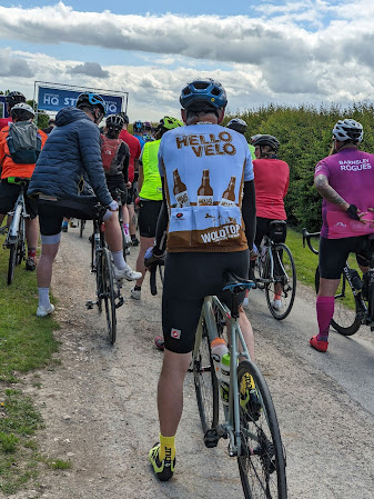
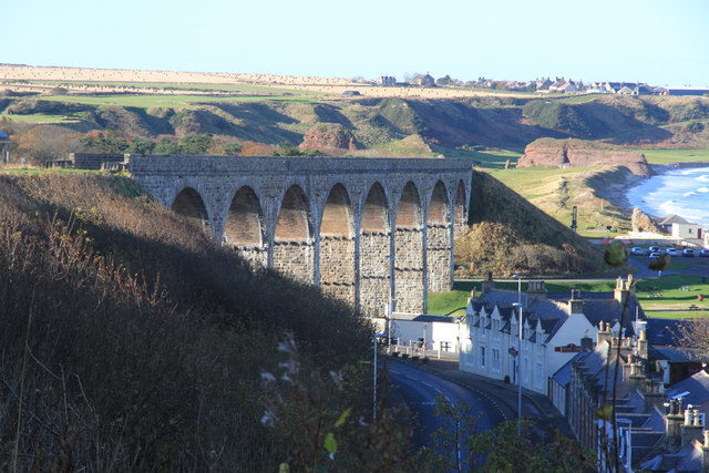
The place was milling with all sorts of cyclists, several looking very professional with their expensive bikes, some looking normal and some looking quite portly. That's the beauty of cycling, literally anyone can do it, you don't need to be stick thin like the pros. Good job really. At a quarter to twelve we were briefed, warned about a couple of potential hazards on the route and then were set off in small groups. I hung around at the back, as I'm not a big fan of riding in groups, and was one of the last few to set off. The drive up to the brewery is quite steep, so when we went through the start gate we had an outstanding view of the Yorkshire Wolds stretching out for miles before us, and had a superb downhill descent to start us off. The first eleven miles were a nice gentle uphill, with the wind blowing from the right, and we were treated to gorgeous views of lush green fields either side, some with sheep and cattle grazing in the sun. I'd ridden this road before, until at West Lutton I found myself on new territory. The road continued to rise, and after Duggleby got steeper for a mile long climb. After this we had a terrific descent of a mile at up to 10%, which ended at a road junction where we turned right to North Grimston. The descending continued gently for another six miles and then climbed for two miles to give another very steep descent into Kirkham, which ended at another junction shortly after a sharp left hand bend. Fortunately we'd been warned about this and I braked in time to avoid potential disaster. Entering Kirkham I stopped to take a photo outside Kirkham Priory, which is an English Heritage property.

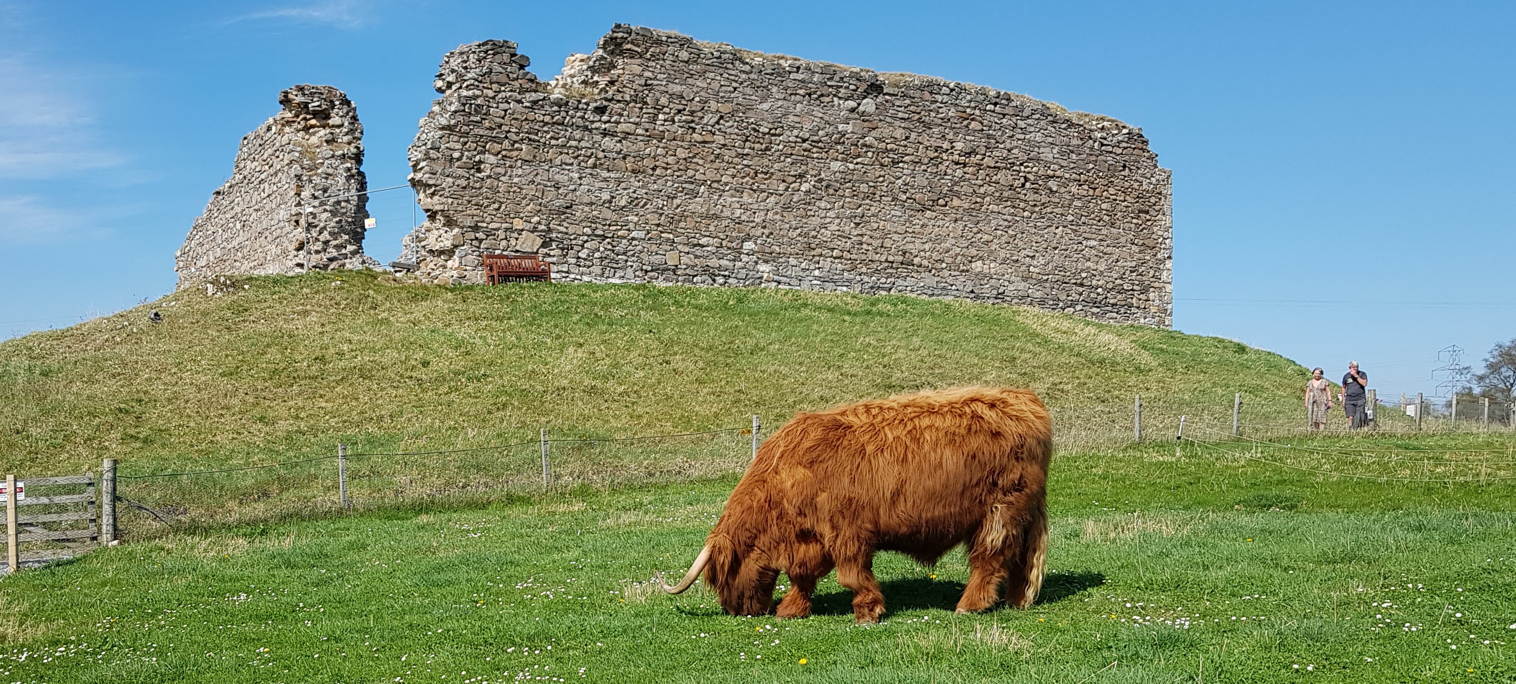
Remounting I crossed the beautiful stone bridge and the York - Scarborough railway line, passed Kirkham Abbey Signal Box and then the road reared up, in places 10%. It was only a short climb, at half a mile, but I passed a few cyclists who were going up on foot. I made it to the top, where we turned left and were treated to a welcome stretch of downhill before entering Riders Lane, which we'd also been warned about. I found this to be not a problem, typical of many farm roads I'd ridden on, with grass growing in the middle the main hazard. I knew we were going to be faced with a long climb before the lunch stop, and when we turned left out of Riders Lane it began - five miles to the top, from sea level to over 700 feet, with gradients of up to 12%. I managed to settle into a good rhythm for most of the climb, passing some cyclists, being passed by others and passing more walking cyclists. I passed one guy who was stopped at the side of the road, preparing to restart, and as I did I heard what sounded like an agonising cry. I slowed and asked if he was ok, he said yes, and we rode on together for a while. He was riding an e-bike, and we discussed their virtues as we went along. He was from Cleethorpes and told me his son was up ahead. The climbing continued but eventually I came to the top, and settled in for the downhill to the lunch stop at Thixendale Village Hall. It was a beautiful winding descent, the road was smooth and flowed really well, and was situated in the middle of two Wolds giving walls of green either side. At one point I passed a small herd of Highland Cows. After three miles of descent I came to the lunch stop, parked the bike and went to attack the food. I settled for a couple of Jaffa cakes, choc chip flapjack, a banana and an orange segment, refilled one of my water bottles and had a cup of coffee. One of the volunteers was asking me about my Wold Top cycling top, and as I was explaining that I used to live in Scarborough but now lived in Sandbach, another rider overheard and said he used to live in Alsager! After twenty minutes I remounted and set off again, the road continuing to descend into another farm road which had some rather nasty potholes in places, at times obscured by shadows from the trees, which made for some rather interesting bunny hopping at times. I'd taken my arm warmers off at the lunch stop, but of course the sun disappeared for a while and the wind made it rather chilly! At Fimber the road ended with a short sharp climb before I turned north east along the B1251 towards Sledmere. I'd driven this part of the course on the way in, so the climb after the next roundabout came as no surprise. The wind was now in my face, making it hard to push the pedals in places. I passed the lovely looking Sledmere House and then turned off in the village to continue heading north towards Helperthorpe, the road becoming a steady gentle descent to rejoin the road we'd ridden out on earlier. A couple of miles further on I turned right for a two mile long drag of a climb up to Eddsfield Airfield. With the wind in my face, there was nothing to do but slog it out, and try to quell the nagging voice that was telling me I was knackered! After the airfield I passed the East Riding Crematorium, the road descending again to head to Octon and then on to Thwing. At one point I fancied I could see the North Sea to my right. After Thwing the road began to drop sharply, but before it did I caught sight of the drive up the brewery far off to my right, and also, ahead of me, the road out of Wold Newton that I knew I would be taking. I'd ridden that when I lived in Scarborough and knew it was a monster of a climb. Before that though, I enjoyed the swift descent which was over all too soon, and at Wold Newton I crossed the main road and began the mile of climbing, with gradients up to 10%. I saw another cyclist in the distance and eventually caught and passed them (slowly!), exchanging our views of the headwind as we passed. At last I reached the top of the climb, and dropped into Fordon, turning right at the crossroads to head back towards the brewery, which I knew to be very close now. Finally I got to the brewery entrance, and started the final climb. The drive is just over half a mile, with stretches at 10 and even 20%, and it almost killed me. I was close to stepping off at one point, fatigue pushing some negative thoughts into my head, but I stubbornly kept turning the pedals and got over the worst of the climb, finally hauling myself up to and through the finishing line. I was very tired, but happy, and headed to the control to sign back in and receive my food and drink vouchers. I headed to the car, even happier to see the tent still up, put the bike in the back and went back for my fish and chips. I looked to find somewhere to sit and eat them, and asked another cyclist if the space on the bench next to him was free. He said yes, then said "Sandbach man?". It was the guy who used to live in Alsager again, and we had a good chat about things as we ate. After the food it was time for a drink, so I went into the bar and got a pint of Headland Red.


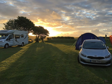
As I was sitting slaking my thirst, the guy with the e-bike sat down at the adjacent table with his son. It turns out his battery had run out just before the final climb of the brewery drive, so we had a good laugh about that. I had another beer, then got showered in a much more impressive shower block than I had been anticipating. Suitably clean and less smelly, I got one more beer at the bar and took two bottles back to the tent. At this point it was getting late, and the sun started setting. The views were just stunning, and I would have sat watching it for a long time but the biting wind made it bloody cold, so I contented myself with popping out a couple of times to get some photos. It was that cold that I dug out and put on my thermal base layer and socks for the next day's ride and sat and finished my beers. I then crawled into bed with my clothes still on, tired, a bit chilly, but contented. It had been a great day, with some fantastic scenery, and I'm looking forward to next year's event already. 


Sunday, May 1, 2022

My final Grantown ride, and what a ride it was

After yesterday's dreich afternoon and evening, I awoke to a slightly misty morning. After breakfast though, the sun had burnt off most of the mist so it was shorts on and off we go. Heading through town I passed a little red squirrel running along the road, and soon after passed the Grantown On Spey Caravan Park, climbing up to West Gorton in the Glenbeg Estate. I walked up one particularly steep bit, conserving my energy for the long day ahead. Soon I was on a wide gravel track, still damp from yesterday's weather, and this took me to a gate to follow a farm track uphill through a field of sheep and lambs.


Passing through a couple of gates I waved a cheery greeting to a couple of farmers. Through more gates, the track became a little rougher, but still rideable. I came across a couple of really big gates, which got me wondering exactly what was being kept in by them - Jurassic Park perhaps! I then came across something totally unexpected - sand, it was almost a beach. This continued for a short while, with hoof prints visible, until the track returned to a typical farm track state. I was high up now, and the views were stunning, making the effort worthwhile. At one point I stopped for a photo opportunity and saw a lovely white an black bird, with a call like one of the new emergency vehicle sirens. Another walk up a steep, loosely gravelled track brought me to the summit of my journey over the mountains, and presented a superb view of Lochindorb, with its castle. I descended carefully and reached Lochindorb Road, where I stopped for an energy bar and a photo.

I noticed the smell of burnt undergrowth in the air, and indeed there were several signs of significant heather fires. Lochindorb Road took me round the southern end of the loch and up to the B9007, which gently rolled northwards. It was good to feel the sun on my back and legs. I turned left towards Dulsie, on an Old Military Road, and came upon what looked like an old bridge that had been built, however this was neither on the road (being six feet to the side) nor did it cross the Tomlachlan Burn (being twelve feet away). I could only conclude that the course of the river had changed and a new road had been built since. Further along, the road turned into a fantastic swooping descent, and dropped onto Dulsie Bridge itself. This reminded me of the Bridge of Alvah, which I'd visited last year, being also a high stone bridge over a river, in this case the Findhorn.

People were jumping off the sides into the river, seemingly a popular pastime here. I continued along the undulating Old Military Road, with pine trees and gorse lining the road, and filling the air with their scents. Just before Little Urchany I turned left onto NCN 1, following this until I left the road to take a detour into Foxmoss Wood, for a spot of forest road and track riding. This then threw me back onto NCN 1, where the Moray Firth popped into view in the distance after coming out of the woodland. I then turned off NCN 1 again for another forest detour, this time through Assich Forest, eventually rejoining NCN 1 at Wester Galcantray. At Cantraydoune Cottage I got my first glimpse of the impressive Nairn Viaduct, and followed NCN 1 down and under, stopping for a couple of photos. I set off again, and had gone a few hundred yards when a train crossed the viaduct. If only I'd waited, I thought. At little further on, at Clava, I headed up towards Culloden to visit the Culloden Moor battlefield, site of the last pitched battle on British soil.

As I walked onto the site, a skylark was singing high above me, although all else was quiet. It felt quite an atmospheric site, and I took a few photos of the little cairns marking the clan burials, as well as the main monument. Returning back to Clava I picked up NCN 7 and popped in to visit Clava Cairns, a group of 4000 year old burial cairns. Back on the road, I continued on NCN 7 south, meeting a few cyclists going the opposite way. I wondered if any of them were doing LEJOG? At Craggie, the road turned left and upwards on the B9154. I slowly climbed upwards, passing Auchnahillin Holiday Park, and the Daviot Care Home. The road levelled out and eventually came to Moy Viaduct, also known as Altnaslanach Viaduct. This wooden trestle bridge carries the single-track Aviemore-Inverness railway across the Allt Creag Bheithen just north of the former station at Moy. This line was opened by the Highland Railway Company in 1897, and the bridge is now the only surviving timber bridge on a main-line railway in Scotland, possibly in Britain.

Further on in Moy, I came across some interesting wooden benches by the side of the road, with carved animals at each end. Eventually the road joined the A9, with cyclists being directed along a path adjacent to the southbound carriageway, before being sent across the road to join a path next to the northbound. This take you through Tomatin, past the distillery and on to Findhorn Bridge, but I turned off after Tomatin to Raigbeg to ride under the very impressive Findhorn (Tomatin) Viaduct, after which I rejoined NCN 7 to grind up the climb to Slochd Summit, the highest point on my return from Culloden. At this point it was mainly downhill back to Grantown On Spey, and I followed the cycle track to where it joined the road into Slochd itself. Just before Slochd, I turned off right to go over the railway line, and I stopped for a photo of Slochd Viaduct just as a train was going over. Sadly I didn't have my phone camera ready to hand! The track continued on through forest tracks on General Wade's Old Military Road, and I found myself singing the song from Sharpe, "Over the hills and far away". My objective was Sluggan Bridge, built in the 1830's, and I reached this after a couple of miles of undulating and variable surface.

From here I rode into Carrbridge, stopping to have a look at the Old Pack Horse Bridge, built in 1717, and also the Village Hall which proudly hosts the World Porridge Making Championship (I kid you not - see www.goldenspurtle.com). I turned off the main road at the Village Hall on Carr Road, and found myself on a cyclists dream ride home - downhill onto a long flat stretch. The sun was warm as I sped along, with the scent of gorse in the air, and came to a bridge over the River Dulnain just before entering Dulnain Bridge itself. Once through Dulnain Bridge I took the old Grantown road (I'm assuming the current A95 was built to bypass Grantown) until it ran out just before Craggan, when I was forced onto the A95. Fortunately this wasn't for long, and I soon nipped off the A95 at Glenbeg Road to enter the town avoiding the A95 roundabout. All that was left now was to follow the B9102 which became the High Street, back to the hotel. A superb ride for my last day in Grantown On Spey, with great weather, a fantastic variety of surfaces, and some superb scenery. A particular highlight was the lack of traffic, with only the A95 before Grantown, the roads around Culloden, and being alongside the A9 having any sizeable volume - indeed between Grantown and Clava I hardly encountered any vehicles. I couldn't have wished for a better ride to end my stay in Grantown On Spey.

Saturday, April 30, 2022

Chasing the train and beating the rain

Today was going to be a rest / tourist day due to heavy legs and forecast heavy rain, however an improved forecast and restless legs meant that I quickly planned a short ride to Broomhill Station on the Strathspey Steam Railway, hoping to lay the ghost of my failed steam train video attempts. I worked out when I'd need to set off to catch the train, and after a quick spot of gift shopping in town I headed out along the Old Military Road to the Old Spey Bridge, crossed the A95 and headed south on the Speyside Way. At one of the gates along the way that needed opening and closing I met a young lad coming in the opposite direction on his mountain bike. We exchanged pleasantries and I casually mentioned that the gates were a bit of a pain, whereupon he equally casually replied "Oh I just usually lift my bike over them". Ah, what is is to be young!

I carried on the track, opening and closing gates, and came to Balliefurth Farm, where I'd encountered the pigs a couple of days ago. No pigs, but a fine looking cow that I stopped to take a photo of. As I was getting ready, the cow lowed, possibly asking me to get its best side! After taking my leave I continued along the track, starting to get a little nervous about the time as there was no sign of my planned turn off yet. The station I was heading for was a terminus, so I had bags of time to play with, but I wanted to get a video of the train entering the station if possible. Eventually I came to my turn, and headed right onto a farm track that soon brought me out on Station Road. I was feeling chuffed with myself, as it was literally a couple of minutes to the station and I had ten in hand, when I heard the sound of an incoming steam train and saw in the distance the 11:21 arrival at Broomhill steaming in a good eight minutes early! There was nothing for it but to head to the station, and onto the platform where the train had pulled up a few hundred yards past. I watched (and videoed) as the locomotive uncoupled and came back down the track to reattach itself to what would now be the head of the train as it headed back to Aviemore.

After taking another couple of videos of the train departing, I too left the station, heading back along Station Road and over Broomhill Bridge, which was opened on November 27th 1894 by The Right Honourable The Countess Dowager of Seafield. I could feel the wind blowing now, quite strongly and seemingly from a southerly direction, and it felt a lot colder than recently. Fortunately at the end of Station Road in Nethy Bridge I turned northwards onto the B970 towards Grantown On Spey, with the wind now at my back. I passed the Nethybridge Hotel, where chairs with white lace trim were being taken into a well mown field opposite. If they were for a wedding I hoped the bride had her coat, and the wedding was to happen before the rain came. Further along the road I stopped to take a photo of the lovely Abernethy Old Kirk, the earliest record of which is in a Latin document from 1187-1203, although the present building dates from 1767. It is a Commonwealth War Graves site with 11 burials there.

In the field opposite there was a woman tending to an allotment, and I thought she had a radio on, but it turned out she was talking to a friend on the phone, quite loudly! Next door to the Kirk is Castle Roy, and I reacquainted myself with Murdo who had moved from a field by the car park to just by the castle walls, where he was contentedly grazing. From here it wasn't long before I was descending to re-cross the A95, and I stopped underneath the Old Spey Bridge to take a couple of photographs. Up close the stonework is impressive, even though it has weathered, and the bridge must have looked a fantastic sight when it was newly constructed. Shortly after, I diverted off into Anagach Woods and, rather than head straight back to Grantown On Spey, I turned right into the woods and followed some great forest track towards Cromdale. The tracks varied in surface, and criss-crossed making it difficult to work out where I was, or should, going. However, thanks to some expert navigation(!) I found myself at the bridge over the Spey at Cromdale.

I'd driven over this the previous day, and it is signposted as a Weak Bridge, with only room for one way traffic. It's an interesting metal girder bridge though, and on the opposite side of the bank to me was a pretty church, belonging to the Church of Scotland. Being at river level there was a bit of climbing to do to get to the B9102 which pointed to Grantown On Spey in a mile and a half. It was starting to spit now, and I followed the road back into town and back to my hotel, just in time to avoid the rain. Another very good day, now for a bit of rest and relaxation.

Friday, April 29, 2022

An unexpected journey, and planning on the fly

Today's trip started in Fiddich Car Park in Craigellachie, where I'd started my Speyside Distillery tour from last September. Driving from Grantown On Spey, I passed Tormore distillery, which I'd 'missed' last year due to me looking in the wrong place. In fact, I'd been looking for the site of the 'former' Tormore distillery, when the one I passed was very much in use and pretty large. I blame Google maps for misinformation! I drove past a few more sites that I'd cycled on in September, and eventually reached the car park. I took the bike out of the car, set off, and within a few hundred yards started climbing. I'd known there was a fair amount if climbing early in the trip I'd planned, but wasn't quite prepared for it to come this early.


It wasn't onerous though, and I plodded on up the hill, reaching a Forestry Commission turn off for Ben Aigan. This turned out to be a steep climb on a wide, reasonably smooth forest track, which just kept going and going. A couple of times I reached a false summit, where it looked as thought the track was topping out, but on getting closer it continued to rise. Thinking the term Speyside was a bit of a misnomer, I continued to climb, eventually reaching a point where the trees gave way and afforded a great view of the Spey stretching out into the distance, far away and a lot lower down than I was. Eventually the track topped out and starting to descend, so I looked forward to a decent stretch of downhill to get back to the river. No such luck! My computer (and the Speyside Way) sent me off down a steep grassy track which unfortunately soon became boggy with standing water, and worse - blocked by fallen trees.

I climbed over a couple, ducked under a third, and squelched along to a point where the grass track eventually rejoined a forest track, turning back on itself to continue downhill. This turned into a rough farm track which, though pretty with gorse in bloom alongside, became a tough ride, eventually spitting out down some steps to join the road at Boat of Brig. The route then ducked under the railway line to Elgin and started climbing steeply again. This proved too much for me following the exertions of the forest previously, and I walked to the top of the climb, not too far. After remounting the road then undulated gently north, before hitting a steep downhill Z-bend followed by steep uphill (on foot again!), just before another Forestry Commission place at Earth Pillars. It continued to undulate before dropping down into Fochabers alongside Ordiquish Forest. At Fochabers I turned left and picked up the Speyside Waya again, which turned out to be singletrack through some woods, with tree roots plentiful. It picked up the River Spey at last, with the surface varying between singletrack and rough gravel. I saw a large heron flying over the river, and tried to get a closer picture of it, although each time I tried to sneak up to it, it must have heard me and flew off again.

By Garmouth the Speyside Way meets NCN 1, which goes over the Garmouth (or Spey) Viaduct. I detoured off over the viaduct, took a few photos and returned, to continue on the Speyside Way up towards Spey Bay, where I stopped at the WDC Scottish Dolphin Centre to chat to a couple who were touring with e-mountain bikes. It turned out their daughter lived near my home, and we compared collarbone injury details. I headed off eastwards on the Coastal Trail and headed inland before coming to Portgordon, where I took NCN 1 and rode on the old railway for a while before being spat back onto the road by Buckpool Golf Club. I followed NCN 1 through Buckie, past the football club, and back onto the old railway to Findochty.

The track became a coastal path then, past Findochty harbour and heading towards Portknockie, also with a small harbour. Here, the track picked up the old railway line again, and continued on to Cullen over a number of viaducts. I left the track and dropped down into Cullen, passing the harbour and pausing at Cullen beach for an energy bar, and to consider how to get back to Craigellachie. I didn't fancy retracing my route from Fochabers up and over to Boat of Brig and then back onto the boggy grass track in Ben Aigan forest, so looked at the options. I decided on heading towards Fochabers on the A98, taking the High Street through town and picking up the A98 again for a short while before turning off towards Rothes and then on to Craigellachie. The A98 was busy in patches, but the motorists were pretty considerate and it never became too daunting a journey.

Although not as scenic as the coastal route, there were a couple of interesting highlights, notably a place called Hill of Maud (Maud being where my mum is from) which looked a pretty damn big hill, and Bells Inchgower distillery. I eventually reached Fochabers and came off the A98 to go through the town, then picked it up after the River Spey before turning left after a few hundred yards onto the B9015. This turned out to be a pretty good, wide road, better than some of the A roads I'd been on, with not much traffic. Best of all, there were few climbs on it, and as I headed south I looked over to my left at the imposing Ben Aigan, and thanked my stars I wasn't heaving my old frame over it. Eventually I came to Rothes and passed the Speyburn distillery before coming across the Glen Grant distillery at a roundabout where I picked up the A941 Perth road. After a few miles I spotted a sign for the Speyside Cooperage Visitor Centre in four miles, and knew then that I was nearly back at the car park.

Just before the road turns left into Craigellachie, I turned right down a wide path to the old bridge at Craigellachie, designed and built by Thomas Telford in 1814 (although the iron bridge framework itself was actually constructed in Ruabon in Denbighshire. After riding over it, and taking a few photos, I rode under the new road bridge into Craigellachie and back to the car park. The Speyside Way through Ben Aigan had left a bad memory on me, but considering we've just had a wet and very windy winter it's no real surprise that the surface has suffered in places. I'm glad I did the ride from Craigellachie up to Spey Bay, and it would be good to ride it again when it is drier. That said, the new route back I worked out turned up trumps, with some great scenery and photo opportunities, and I'm glad I took that option too. Just goes to show, sometimes you don't get the ride you were expecting, but good planning skills are essential to cope with those circumstances.

Thursday, April 28, 2022

Water and stones - Scotland 2022 day 2

A late change of plan saw me decide to take the trip south to Ruthven Barracks today. After setting off from the hotel I made my way to Forest Road where I came across some lovely forest track (as you would expect!). I followed this along and after a couple of wrong turns, going back and forth, I eventually found myself on the Old Spey Bridge. Here I stopped for a photo and to reset my bike computer, which got confused by my toing and froing. While I was doing this, a friendly little red squirrel hopped onto the parapet, staying around just long enough for me to pull my phone out, at which he promptly disappeared, a little camera shy!


Having sorted my computer and with directions, I headed off, crossing the A95 and taking the B970 towards Nethy Bridge. The road undulated gently and after a few miles I came across Castle Roy, and it's guardian Murdo. The castle was built between 1190 & 1220, Murdo is somewhat younger. The Spey valley lay to my right, looking very lush in the morning sunshine. After passing Abernethy Golf Club, I came into Nethy Bridge, the bridge over the River Nethy being very pretty indeed with a row of daffodils lining the river bank. Leaving Nethy Bridge I continued on the B970, stopping every now and then to take a photo of the gorgeous scenery. I came across lovely river vistas, donkeys, and Loch Pityoulish, where it seems some people were wild swimming! Eventually I reached Coylumbridge and a junction, where I turned right past the Coylumbridge Hotel. Shortly after this, I turned left onto what eventually became the Old Logging Road, a rough gravel track that lead towards Loch An Eilein. I stopped here for a few minutes, enjoying the quiet, the clear water and the views out towards the mountains. Suitably refreshed, I retraced my route to the Old Logging Road then continued on to rejoin the B970, where I turned left and headed towards Feshiebridge. The road, as most in this area, was rolling and I had moments of speeding along nicely only to be brought to a slow crawl again as the road rose up. Still, the scenery continued to impress, especially when the trees opened out and showed views over towards the Spey.

At Feshiebridge, the road turned sharp right over the River Feshie, which was giving a good show of waterfalls over the layered rocks. I came across a group of young kids on bikes here, chaperoned by a couple of presumably teachers. I think I lost my intended route here, but continued on the B970 which was also NCN route 7. At another sharp right the road crossed the River Tromie, which was also producing a good torrent of white water. The road then passed the RSPB Insh Marshes, before reaching the imposing Ruthven Barracks, a small 18th century garrison built between 1719 and 1721. Standing on a mound, it is easy to visualise how dominant and foreboding it would have looked shortly after being built. Leaving Ruthven Barracks behind, I followed the B970 into Kingussie, turning right away from NCN 7 and going through the town. The road eventually became the B9152, and at one point outside Lynchat there were flocks of gulls and ducks in the fields on either side, making an unholy racket over something. Further on the road passed the Highland Wildlife Park advertising a Polar Bear Cub, followed by a sign for Working Sheepdogs. I wondered what sort of working they did, admin, manual??

At Kincraig I turned off  to have a look at Loch Insh, although truth be told I only made it to the bridge over the River Spey which afforded a fantastic view. Rejoining the road I continued on towards Aviemore, pausing at Loch Alvie for another photo stop. Entering Aviemore I turned off to go behind the railway station, passing the Strathspey Steam Railway where I saw a coach from Bideford, near Barnstaple where my mum and sister live. I picked up NCN 7 again here, passing a splendidly painted route marker and passing the Cairngorm Brewery (pausing to see if there was a bar / shop open), and eventually passing under the railway through a very narrow tunnel. This brought me onto a nice gravel track through some woods, which I followed until my computer beeped at me to indicate I was off course. I retraced my steps, as I hadn't seen any obvious path off, and saw what could have been a track, although it was going almost vertically uphill. I pushed to the top of this, and sure enough there was something that looked like a singletrack trail. I followed this, which was rideable but would probably be best described as gnarly, having roots and pebbles to trap the unwary rider.

This wound its way up and down before eventually rejoining the gravel track, which gave a glorious sweeping through the woods into Boat of Garten. Aside from the gnarly off-off-road piece, which I'd probably avoid if I rode the route again, the journey from Aviemore to Boat of Garten turned out to be great fun. I knew at this point that the Strathspey Railway was running today, and was hoping to get a video to send to my father-in-law, having failed three times before to get something on camera for him. As I was passing the holiday chalets on the outskirts of Boat of Garten I heard the unmistakable rattling and clunking of a steam train, and glancing to my right I saw the roofs of the carriages passing below. The curse of the missed train video strikes again!! I called in at Boat of Garten station to see when the next arrival was, but sadly it wasn't for another hour. My disappointment soon abated when I left the town and crossed the Spey, where I got a great shot of the river with the snow covered mountains behind. At the end of the road I came across the B970 that I ridden down before, and instead of turning onto it I crossed into Abernethy Natural Nature Reserve to take a track that I'd noticed from the road earlier.

This turned out to be a typical forest singletrack, being lumpy and soft and slower than being on the road, however I persevered and eventually popped out onto the road leading towards Loch Garten. I stopped for more photos then continued on past the Loch along rolling roads through forest to eventually rejoin the B970 outside Nethy Bridge. At the bridge, this time I turned off the B970 to pick up the Speyside Way by Nethy Bridge station. This had a grassier surface than I'd seen in other parts of the Speyside Way, which was a little lumpy in parts. There were also several gates to pass through, as it passed by several farms, so progress was a bit stop go. At Bailliefurth Farm the track to a diversion past the farm yard, and on picking up the original way again I came across a small group of light brown pigs with darker spots, as well as a sign post indicating I was only 3 and a half miles from Grantown On Spey. Just outside Grantown the track got closer to the River Spey, and I stopped to take a photo of the new Cairn Distillery that is being built alongside the river, due to open for visits in Spring 2022.

In due course I came to the end of the Speyside Way at the A95, and crossed over to return to Grantown. I decided to stop for tea at the brilliant Grantown East, a Highland Heritage and Cultural Centre that also has two old railway coaches where you can get something to eat. Having worked so hard on the road, I decided to go for a Locomotive Breakfast pizza and a cappucino. I have to say it was a great decision, the pizza was probably the best I'd ever had! Suitably refreshed, I got back on the bike and headed back to the hotel, through the delightful forest track again, where a hot bath was calling me. 

Wednesday, April 27, 2022

Spring has sprung - Scotland 2022 day 1

When I woke in the morning the temperature outside was below freezing, so not unnaturally I chose my outfit accordingly. After breakfast, when I got round to setting off, it had risen to three degrees, and the forecast was for a top temperature of 12, so I was more bothered about nippy fingers and toes at that point. I set off out of the hotel and chose my route on the bike computer, however I didn't realise until I set off that the reverse route I'd created hadn't synced! Not a problem I thought, I'll just follow the original but going backwards. I set off along a B road out of Grantown On Spey, past the golf club where a few hardy souls were teeing off. It was a quiet road, and I was only passed by one car in the first half hour. The road undulated in a fairly benign way, nothing too strenuous too start with. I passed several fields with sheep and cattle, and there new offspring, I also came across a couple of sizeable rabbits playing on the road.


Shortly after this, I came down a left handed descent and was presented with my first view of the River Spey, and what a glorious sight (and sound) it was! A little after, the road rose up and presented me with my first stiff challenge of the day. I puffed up it, noting with a little concern that my chain was making a right racket in bottom gear. At the top of the climb and looked backwards and drank in the view of the Spey plain with the mountains behind. The road continued to undulate with the Spey always on my right hand side, and at a turn off for Advie I took a quick detour to snatch a couple of photos of the river from the bridge. Further on I passed an entrance to something that I had a feeling I should have taken, as it looked like it dropped onto the Speyside Way, however I continued on the road and eventually picked the Speyside Way up at Blacksboat, I'd been here in September last year, and bemoaned the state of the surface, and it looks like they are still working on it, as a couple of little dumpers were beavering up and down. It looked like they were dropping something onto the rocky surface with a view to flattening it, however at one point the way was barred by a skip with a dumper behind. I prodded the newly flattened surface to see how it stood up, and I left an impression of my foot! I decided to walk on the side for a few hundred yards to avoid ruining the new surface, but eventually it firmed up so after further testing I hopped back on the bike and rode on. After a short while, the new surface stopped and the old ballast-like surface returned. Fortunately it wasn't long before this too disappeared and the Tamdhu cooperage came into view, and here I left the Speyside Way and headed up the hill towards Cardow. Passing the Cardhu distillery, I turned onto a bumpy farm track just before Knockando Primary School and rattled on to a lovely quiet road, where I turned left.

From this point, the thing that struck me was the amount of gorse that was flowering, there seemed to be yellow flowers everywhere for miles along the road. The trees were also producing copious amounts of blossom, making for a very scenic ride indeed, particularly as the road undulated and as it was quiet I could flow down the hills into the corners nicely. Eventually I came to the junction with the road for Forres where I turned right and started climbing again. My chain started it's infernal racket again so I stopped and managed to fix the issue, climbing became quiet again (apart from my laboured breathing of course). I was getting very warm at this point, as my winter clothing couldn't cope with the sun which typically shone when I was putting an effort in, and when I was coasting downhill it went behind the clouds! After a long bit of climbing the road started undulating again, and after a while I came across a village called Dallas! Sadly there was no South Fork farm around. Soon I turned left at a junction and started dropping down towards Forres, through a lovely village called Rafford. In Forres, I came across a brightly painted Highland Cow statue, one of which I'd seen in Grantown the previous evening.

Further on I headed to Sueno's Stone, a 7m Pictish cross slab featuring carvings of a battle. After I took a couple of photos I headed back into town and treated myself to a coffee and sandwich at Cafe 1496, a little pricey but given the size and quality of the sandwich I had no complaints! After lunch I found the start of the Dava Way, which follows the line of the old Highland Railway for 24 miles between Forres and Grantown On Spey. Like a few disused railway lines, the surface varies considerably, in some places hard packed dirt, in others it seems they have left the ballast lying around which makes it tricky, and in others it is soft grass which sucks at your wheels. There were a couple of deviations from the original route on the Dava Way, and at times it turned off into the forest at either side onto forest tracks. There were great views on either side at times too, although at other times trees obscured the view (or hid the railway I guess). Shortly after the start of the Dava Way it goes past the disused Dallas Dhu distillery which still offers self guided tours. There are many informative Way Points which give information about interesting things along the way, including a wind farm trail, a viaduct, a bridge which allowed livestock to cross a river underneath, an old croft building and a couple of lineside buildings, all of which gave me opportunities to take a break from the long uphill plod to the highest point. I was looking forward to a downhill stretch into Grantown when the signs unceremoniously pitched cyclists and horse riders off the track and onto the A939. Although not a busy road, cars were still speeding past and while it didn't bother me a great deal, I could imagine horses and inexperienced cyclists not enjoying it. As it was, the lack of return signage to the track meant the last few miles were becoming a boring road slog, when out of the corner of my eye I spotted a blue finger post in a turn off.

This, it turned out, put me back on the Dava Way albeit through a forest switchback for a while until it seemed to return to the 'proper' disused railway. This crossed the A939, and headed into Grantown On Spey through what appeared to be a rock cutting, at one point a waterfall was turning the right of the track into a stream. I reached the end of the track by Grantown Caravan Park and dropped down into town to head back to my hotel where I treated myself to a hot bath, a pint and fish and chips. Heaven.

Saturday, February 12, 2022

Tour of Scotland 2022, it begins....

I'll be doing another tour of Scotland later this year, and once there I'll no doubt be enjoying some superb jaw-dropping scenery in fantastic cycling countryside. There is that well-known quote though - life is about the journey, not the destination - and whilst the enjoyment of the physical cycling is yet to come, I've had a very enjoyable time in researching and planning the rides that I'll do.

Grantown East Highland Heritage and Cultural Centre 

First thing up is to decide where to ride. Scotland is a big country, and there are plenty of places to choose from. However, after last year's ride around the Speyside distilleries, I really wanted to go back to the Highlands and Cairngorms area, so that became my choice. Next question, where to base myself. Looking around the region there were a few possibilities, but for the range of options for riding I narrowed the options down to a shortlist of three; Aviemore, Boat of Garten or Grantown-on-Spey. I thought Aviemore may be too commercialised and busy, Boat of Garten probably too small to have a decent choice of accommodation, so in a Three Bears kind of way I plumped for Grantown-on-Spey, which had the distinct advantage that the Dava Way, a 23 mile cycling route along the former Highland Railway line, starts there, so that was one easy option for a good ride. From Grantown-on-Spey it goes north to Forres, and from there I could return via Knockando and the Speyside Way, retracing some of the route I did last year.

Next thing was to look around the area and try to work out some good routes in all directions. The Visit Scotland website was a good source of material here, and there were a number of rides detailed on the site that I could make use of. Using these I came up with four more routes; north west to Culloden, south west to Ruthven Barracks, east to the Glenlivet Estate and a circular Boat of Garten - Carrbridge tour. That done, I started looking at the rides in more detail, looking for interesting things off the planned routes that could be worth a diversion. Google Maps was a very useful tool in facilitating this, and I had a great time digging out some fascinating places to call in on. I also started tweaking routes that overlapped, choosing alternative roads or tracks where these existed to give a more varied itinerary. 

With a ride going to Culloden, I will be visiting the Culloden Battlefield itself, and this has given me the opportunity to read about the famous battle (albeit briefly). In addition to this, I noticed there were a lot of roads called Old Military Road in the region, and whilst I'd seen a couple of rides that followed the Old Military Road I thought there was only one, built by General Wade. Turns out there are quite a few covering the area, and as well as roads General Wade built bridges. I noticed there was one at Sluggan, so tweaked the Culloden ride to make sure I rode over it.

Sluggan Bridge on General Wades Road - YouTube
Sluggan Bridge


Whilst the Culloden visit will be a good opportunity to find out more about 18th century history, there will be places I visit that pre-date that; Clava Cairns near Culloden is a group of Bronze Age chamber tomb cairns, whilst Sueno's Stone is a gigantic Pictish cross slab in Forres. Carrbridge has an 18th century Old Packhorse Bridge. To the south of Grantown-on-Spey, Castle Roy is a 12th century fortress with it's own Heilan' Coo that can be sponsored!

Sunny day 

In addition to the historical aspects of the tour, there are many Lochs that I'll be visiting, a few railway viaducts I'll be passing underneath, a couple of whisky distilleries and the place where the World Porridge Making Championships are held! The latter I found out thanks to one of Michael Portillo's Great Coastal Railway Journey programs, which also showed Cullen viaduct on the Moray Coastal Cycle Trail. That inspired me to look at that particular route, and I subsequently worked out a suitable day ride along it which will probably replace the Glenlivet Estate ride. Sadly, I won't be able to go to the fish shop that appeared on the program to try some of their famous Cullen Skink!


Cullen Railway Viaduct © Alan Hodgson :: Geograph Britain and Ireland
Cullen Viaduct

I'm really looking forward to this trip. There will be plenty to keep me interested along the way, and hopefully as I am planning to go in March or early May, I'll avoid the dreaded midges! I'm sure I'll continue to research the routes up until the date of departure, and will tweak any as appropriate. Planning is certainly an enjoyable part of cycling, and hopefully the work I've done will ensure a very enjoyable trip.