Tuesday, January 4, 2022

Happy New Cycling Year!

It's that time of year again, the start of a new year, carrying a load of extra timber following the Christmas celebrations, time to look forward and plan out what to do on two wheels this year. It can be difficult getting out in January due to the weather and loss of fitness, but thanks to the unseasonably mild weather I've been out twice already. The second time I was feeling tired and a little hesitant about going out, but after ten minutes or so the feeling of happiness at being out and moving under my own steam kicked in, and I enjoyed a great couple of hours. I have frequently found that a ride that started in tiredness and lack of motivation quickly changes into one of tremendous enjoyment and fun. It's one of the benefits of exercising, the endorphins kick in and all is well with the world.


I've never set any real cycling goals in previous yeas, however for 2022 I decided it would be useful to put something down on paper. The first one is one I was looking at last year - doing a century ride (i.e. 100 miles). I'd almost done this twice when completing the Devon Coast to Coast in 2019 for Cancer Research, however I 'only' managed 96 and 95 miles over the two days. I've already got a route planned, to include refreshment stops at sensible points, it's just a matter of getting back to the required level of fitness and waiting for a good day weather wise.

My second goal is to ride 5200 miles this year. Last year I rode 4600 miles, in a year that was hampered by my broken collarbone at the end of June, and various illnesses towards the end. I keep a count of my 'rolling year' mileage total, and up to the point of my accident had got to over 5300 miles in the twelve months to the end of June. Hopefully I can steer clear of illness and injury this year and hit that target.


I'm also hoping to do some more riding in other areas of the country, Scotland again perhaps, rougher areas of the Peak District (rough surface that is, not suggesting there are any dodgy places in the Peak District), something to make a change from the local roads that I am more than familiar with after more than three years of cycling on them. Above all, I want to ensure each ride is as enjoyable and fun as it can be, and that I never lose my love of riding a bike.


Friday, September 17, 2021

Scotland 2.0, Day 5: Holiday ends with a bang, but not in a bad way this time

Must admit I was looking forward to this trip with some trepidation. I'd been feeling tired in the mornings, this was the longest ride at 64 miles, and there was a strong southerly wind blowing which suggested a headwind coming back. Nonetheless I set off and took the F&BW to Maud. It felt like an old friend as I cycled along, and getting to Maud I followed the same route as I'd taken on Monday for a while. Traffic was light again, I even had a van driver wave at me. I followed NCN route 1 out of Maud, which turned out to be a very good ride, on quiet roads, and passed a signpost for Oldwhat


before crossing the road from New Byth to New Deer. Here, the road descended into Cuminestown and then turned right to ascend a hill and go past Dalgety Forest. I spotted a bike outside someone's home that had been decorated with flowers in pots, something I'd seen several times before. From here the road descended into Turriff, a fairly large town, and quite busy with traffic. I'd come through here on my way to Speyside, and had noticed that NCN1 turned off the main road up what looked like a fairly steep hill. When I got to the turn off, the steep hill turned out to be not so bad, and only ascended for a short distance. The wind, which had been cross-head from the left previously, was now fairly helpful, and I made good progress along the rolling road. It wasn't long before I spotted the River Deveron far below me on my left, although it was partly obscured by trees in the fields below me. Further on, the trees disappeared and I got a full view of the Deveron as it wound its way towards Banff Bay. There were even a couple of fishermen plying their trade.
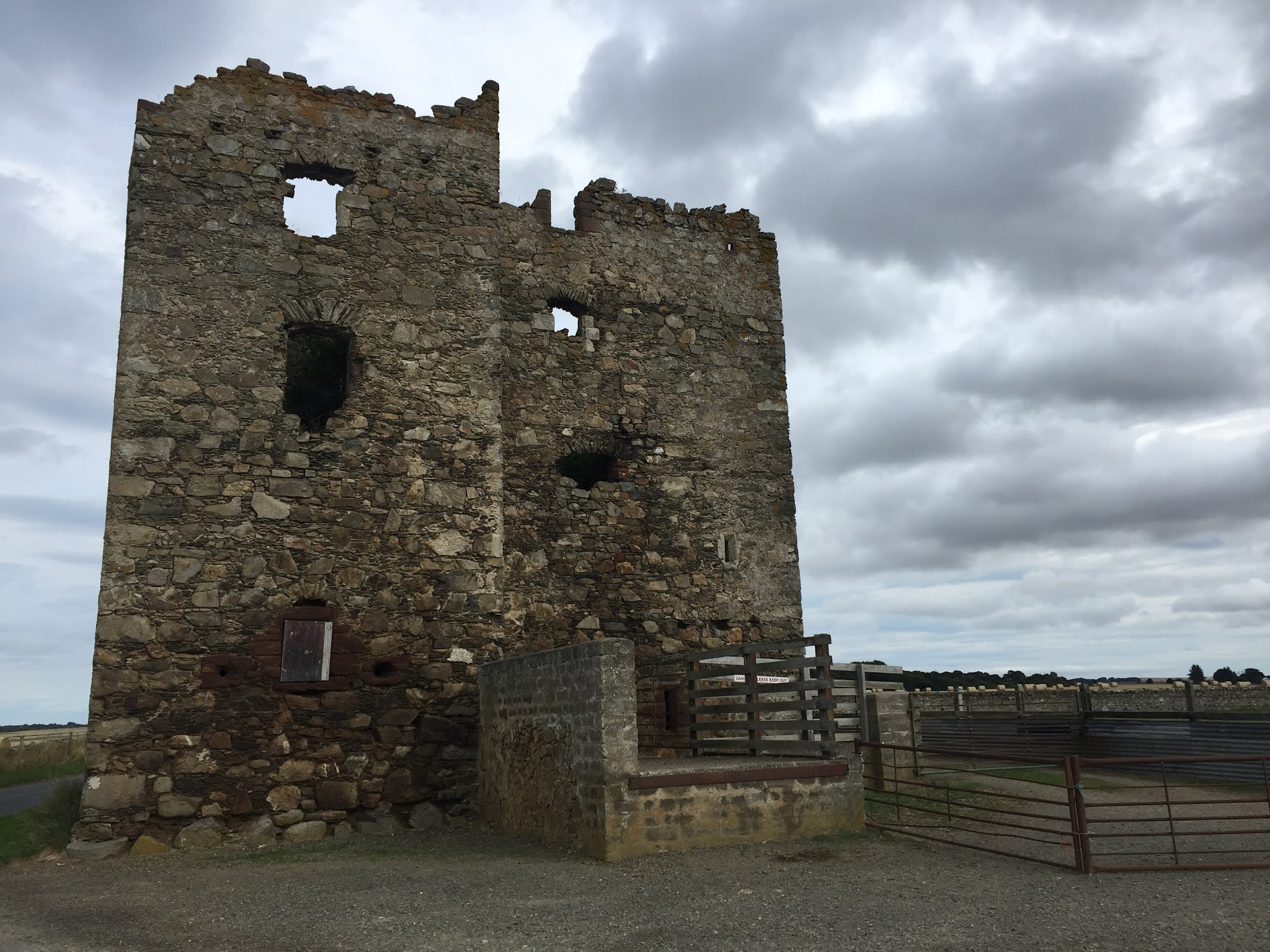
Eden Castle

Later on the road I came across a stone bridge over a stream and stopped to take a photo. As I crossed it, I noticed a sign for Eden Plants, and a little further on came across the remains of Eden Castle, a 16th/17th century towerhouse. More interesting sights were promised later on, with a sign saying "Warthogs". Sadly, this turned out to be not a herd of tusked pigs, but a "paint your own pottery" place. Why Warthogs I've no idea. Shortly after this, I left NCN 1 and headed down what turned out to be a very rough track for the Bridge of Alvah, something I'd noticed on Google maps when planning the route. It turned out to be well worth the tricky approach, an 18th century bridge over the Deveron in a gorge, and gave superb views in either direction. Leaving this, again via a tricky track, I noticed another track on the right, and thinking this was a route into Duff House took a chance and followed it, departing from my planned route. It turned out I was right, and after a while I passed the Duff House Mausoleum in the woods, another 18th century construction. Following the road through the grounds I eventually came to the main road, and had to work out how to get back on track. This done, I climbed through Banff, past Banff Academy, and dropped down into the sea front at
Boyndie Bay

Boyndie Bay. The sun was out by now, and the water was incredibly clear. Loads of cormorants and gulls were sunning themselves on the rocks. I followed the seaside path into Banff and past the Marina, before leaving the town and going over the impressive bridge over the Deveron into Macduff. I turned off the main road before entering the town, climbing up past the old station which is now a Home Styles store, and stopped for a breather overlooking Macduff harbour. After a drink and something to eat I dropped through the town and past the ships berthed in the harbour, past the shipyards, past Macduff Marine Aquarium and out to Tarlair swimming pools, where my sister remembers playing on one of our holidays in Scotland. After taking some photos I climbed back up to the main road, where the full force of the wind now was in my face. I crawled up the road to the turn off for the coastal route, where it indicated 6 miles to Gardenstown.
Gardenstown

As I had studied the route profile the previous evening, I knew this meant 6 miles of ascending to reach the high point of the trip, which was good, as it meant I knew where the end of the climbing was, but also bad, as it meant six miles of climbing. At least the wind was a little helpful for some of the time. After what seemed an age I spotted a village on the coast, and soon after turned right for what I knew was a little bit of climbing but then a good stretch downhill. Unfortunately this coincided with a full on headwind, so again it was a case of stick it in the small ring and pedal. After a while I came to a turn onto what looked like a farm track, marked Shepherds Loch. This turned out to be another rocky climb, past a small loch which I assumed was the Shepherds Loch signposted, and past a few more houses and farms before reaching a small road, where I turned right and dropped down onto the main road. I think I planned this so that I wouldn't have to spend too much time on the bigger A roads, but to be honest the traffic was that quiet on this one that it would have been easier to stay on the main road. Hey ho, who doesn't love a hard, not strictly necessary climb!

The wind was blowing from the side on this road, and I made good progress, until I turned right off the main road and into the wind again. This road eventually turned eastwards and I arrived at New Pitsligo, where I spotted a garage called Aldersyde Motors. Leaving New Pitsligo, the road took me past some nice forested areas, where the air was filled with the scent of pine needles. Eventually I rode past a sign for Strichen Stone Circle, which I'd seen on day 1, and sure enough I found I was riding beside the F&BW between Strichen and Maud. I was sorely tempted to jump on this and make it a reasonably flat ride back to the B&B, but resisted the temptation and continued into Strichen. Taking the road for Deer Abbey out of town, it soon climbed, making me wish I'd taken the F&BW! Soon though, I spotted a couple of swans with seven cygnets, and stopped for a photo. It was a quick photo as the parents were starting to take an interest in the stranger who had stopped by the fence. The road continued to climb, passing fields with stacked square hay bales, rather than the standard circular

ones that seemed to be the norm. Soon, it was passing more forest areas, and a sign for Louden Wood Stone Circle, which I ignored as I was ready for stopping and a hot shower by now. At the end of the road I turned onto the Maud - Old Deer road and should have turned right a little later for the B&B. However, the sun was shining, I was feeling quite good, and despite the wind I wanted a final ride on the F&BW back from Old Deer to the B&B, so I continued on. It took a while, due to the headwind, but I eventually turned onto the F&BW and rode past Deer Abbey in the opposite direction before returning to Old Deer and the B&B. For all the misgivings at the start of the day, it had turned out to be a real cracker of a ride, even with the annoying wind, and was a perfect end to a fantastic week of cycling in Aberdeenshire.

Thursday, September 16, 2021

Scotland 2.0, Day 4: The effects I have on cows......

After yesterday's exertions I was woken by the alarm, feeling heavy legged and tired. It was drizzling too, so I delayed my start today to let it blow through, and also took some time to do some bike maintenance to sort out the creaking I heard yesterday. At least I think it was the bike, could have been my joints of course. Eventually, I set off just after half past ten and joined the F&BW in Mintlaw, heading towards Peterhead. The track was a good, wide surface surrounded by lush vegetation, and as it
Tunnel of trees in Mintlaw

was autumn there was a carpet of fallen leaves and other detritus to ride through. The up side of this is that several times I was riding through corridors of trees, which is a really nice feeling. After Mintlaw the trees became less and vistas of fields opened up. I came across a rare sight - an unharvested wheat field, which surely must be due for collection shortly. As I stopped for a photo I heard the unmistakeable cries of two buzzards, followed shortly by a chicken - I pondered on a posible conversation with the buzzards discussing lunch, and the chicken telling them to sod off! Shortly after I came across another F&BW sign board, which had an unusual addition of a bag of dog poo hanging from it. It always amazes me when I see these, if the owners can be bothered to bag it why don't they take it with them!! At Longside the track crossed a road and continued onwards, past a locked portaloo. Shame there aren't any of these around when a desperate cyclist needs one, as the only alternative is to splash a few weeds. As I rode on, numerous signs popped up indicating local walking routes, clearly there is a good network of paths available here. I also noticed that the track was now dead straight, rather than meandering as it did
Not a curve in sight

elsewhere, and you could see a long way in the distance. Soon I found myself on the outskirts of Peterhead. At this point, the track turned into a properly tarmaced path and threaded its way past houses and supermarkets. I think the routes lose their identity somewhat when this happens, out in the open countryside you can feel the history and purpose, but once in urban areas it just becomes invisible in the urban sprawl. It's a shame, but better to have it there than not, and we do have a lot to thank Dr Beeching for. I left the F&BW and navigated through the streets of Peterhead to the harbour and beach. I have a photo of me with my Nan on this beach, me jokingly trying to strangle her. There were a number of ships in the harbour, with the strange look of a Japanese bullet train to them. I left the beach, passing the Scottish Maritime Academy, and took the shared path running alongside the A982. I was glad of it, as the traffic was heavy with some big lorries rolling along. A little further along the road I saw a sign for a viewpoint, so decided to divert to see if it was worth it. Short answer - no! The view was a small bit of the sea and a large bit of the SSE power station. It definitely wasn't worth the climb up a steep grassy path, pushing a heavy bike. At least there was a picnic table and a waste bin, so I had a drink and one of my bananas before setting off again. A little further on I turned off the road into Boddam. This is a
Boddam lighthouse

small village with a harbour and a lighthouse - definitely worth the divert and with a better view than that at the viewpoint! From Boddam I climbed back up to the road and retraced back towards Peterhead for a short distance before climbing inland. Midway up there was the remains of a ruined cottage that had superb views, if it could be renovated it would be worth a fortune. The road continued up and turned back southwards, and after a bit of a rollercoaster ride I eventually crossed the A90 again and dropped into Cruden Bay. At this point the sun came out, and I found myself at the gorgeous Port Errol Harbour overlooking the Bay of Cruden. It was absolutely beautiful, so I stopped for lunch. It was tough to drag myself away from there, but I knew if I didn't I'd seize up. I climbed out of Cruden Bay, passing a beautiful church building, and reached the main road again, which I crossed and headed in the direction of Hardslacks. The road climbed steadily for five miles, affording superb views across the countryside in the sun. At one point I came across a herd of cows eating feed from a huge trough, so stopped for a conversation.
Hrrraaauummmphh!

All I got was blank stares, and one of them started coughing loudly at me, so I pedalled off again. After a bit of strenuous ascending I came to the highest point of the ride and started descending, still on rolling roads. I came to the A952 road that I'd taken when driving up here and followed it for a short distance before turning off at the wonderfully named Clola. Straight away I was climbing again, so to take my mind off the exertion I started playing word games with the name - Coca Clola, Clola Rodgers (one for the oldies). I stopped when I came across of field of very large cows moving towards the road, one of them having a good scratch on a gate, so good that I was worried about the gate giving way and me having to sprint to avoid a raging herd. I noticed at this point that not only were the roads quiet, but there were far fewer herds than I'd seen earlier, and also fewer birds, certainly no buzzards or the like. I knew I was due to make a right turn to drop down into Maud at some point, and was expecting it at any point, but each time I thought this was it, it turned out not to be. Eventually though I did come across a signpost for Maud, 3 miles, and followed the direction. As I rode along I noticed a small herd of alpacas in a field on my right. An unusual first for me this week.
Highland cow (original)

Further along again I came across four small highland cattle. Three of these were black, which is the original colour for the breed. The reddish coloured variety was popularised by Queen Victoria who commented that she preferred these, and so in an effort to please her selective breeding took place to encourage growth of these and black cattle gradually declined over time. I stopped for a photo, which so clearly excited one of the little black fellows that he started  urinating, and one of the others started a coughing fit too! After what seemed an eternity I eventually passed Maud Hospital and descended Bank Road, passing my nan's old house. I did a quick turn round Maud, taking videos for my mum to see, then picked up the F&BW to Mintlaw, ending back at the bed and breakfast shortly after three, after another cracking day on the bike.