Friday, September 17, 2021

Scotland 2.0, Day 5: Holiday ends with a bang, but not in a bad way this time

Must admit I was looking forward to this trip with some trepidation. I'd been feeling tired in the mornings, this was the longest ride at 64 miles, and there was a strong southerly wind blowing which suggested a headwind coming back. Nonetheless I set off and took the F&BW to Maud. It felt like an old friend as I cycled along, and getting to Maud I followed the same route as I'd taken on Monday for a while. Traffic was light again, I even had a van driver wave at me. I followed NCN route 1 out of Maud, which turned out to be a very good ride, on quiet roads, and passed a signpost for Oldwhat


before crossing the road from New Byth to New Deer. Here, the road descended into Cuminestown and then turned right to ascend a hill and go past Dalgety Forest. I spotted a bike outside someone's home that had been decorated with flowers in pots, something I'd seen several times before. From here the road descended into Turriff, a fairly large town, and quite busy with traffic. I'd come through here on my way to Speyside, and had noticed that NCN1 turned off the main road up what looked like a fairly steep hill. When I got to the turn off, the steep hill turned out to be not so bad, and only ascended for a short distance. The wind, which had been cross-head from the left previously, was now fairly helpful, and I made good progress along the rolling road. It wasn't long before I spotted the River Deveron far below me on my left, although it was partly obscured by trees in the fields below me. Further on, the trees disappeared and I got a full view of the Deveron as it wound its way towards Banff Bay. There were even a couple of fishermen plying their trade.
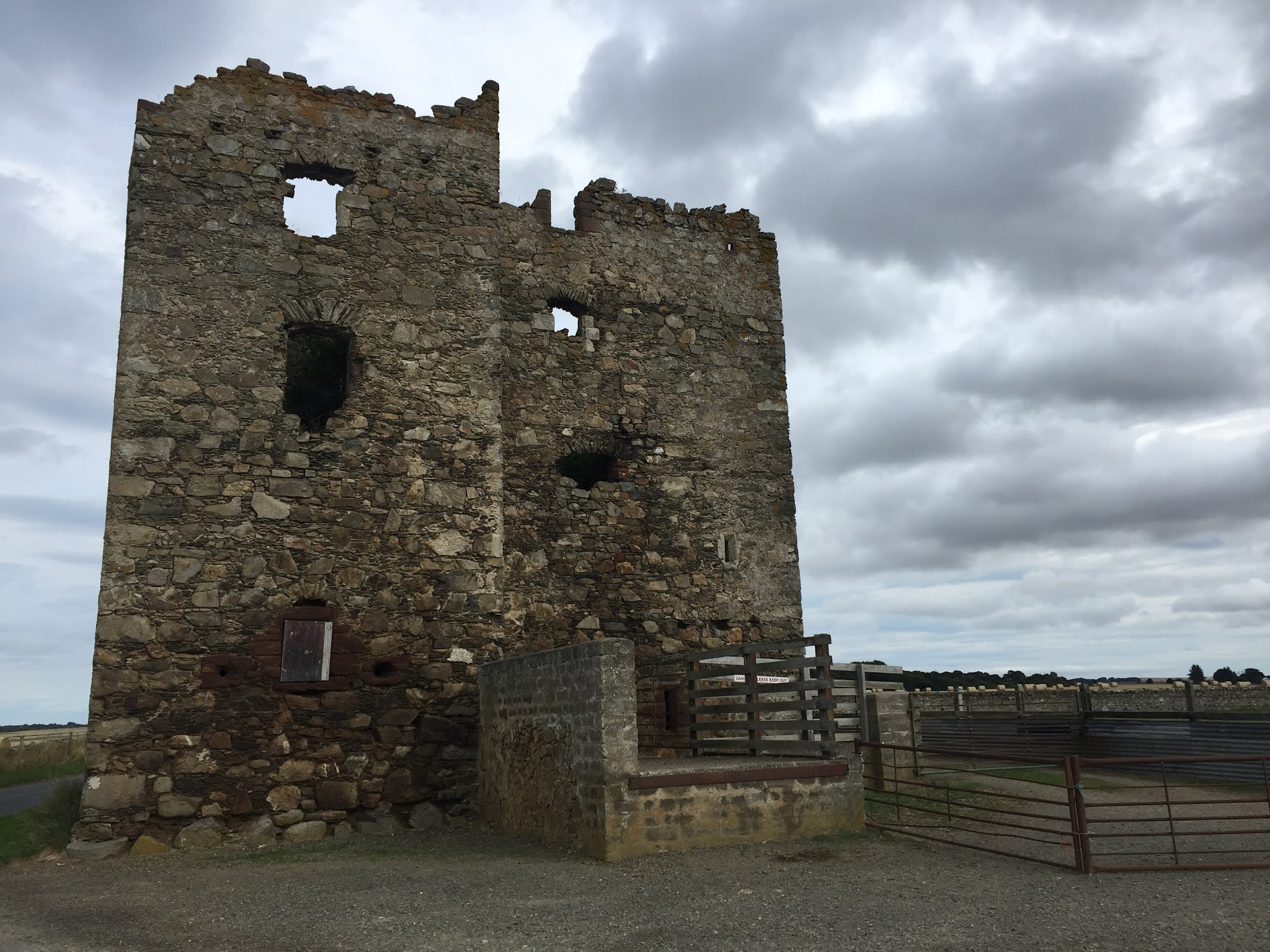
Eden Castle

Later on the road I came across a stone bridge over a stream and stopped to take a photo. As I crossed it, I noticed a sign for Eden Plants, and a little further on came across the remains of Eden Castle, a 16th/17th century towerhouse. More interesting sights were promised later on, with a sign saying "Warthogs". Sadly, this turned out to be not a herd of tusked pigs, but a "paint your own pottery" place. Why Warthogs I've no idea. Shortly after this, I left NCN 1 and headed down what turned out to be a very rough track for the Bridge of Alvah, something I'd noticed on Google maps when planning the route. It turned out to be well worth the tricky approach, an 18th century bridge over the Deveron in a gorge, and gave superb views in either direction. Leaving this, again via a tricky track, I noticed another track on the right, and thinking this was a route into Duff House took a chance and followed it, departing from my planned route. It turned out I was right, and after a while I passed the Duff House Mausoleum in the woods, another 18th century construction. Following the road through the grounds I eventually came to the main road, and had to work out how to get back on track. This done, I climbed through Banff, past Banff Academy, and dropped down into the sea front at
Boyndie Bay

Boyndie Bay. The sun was out by now, and the water was incredibly clear. Loads of cormorants and gulls were sunning themselves on the rocks. I followed the seaside path into Banff and past the Marina, before leaving the town and going over the impressive bridge over the Deveron into Macduff. I turned off the main road before entering the town, climbing up past the old station which is now a Home Styles store, and stopped for a breather overlooking Macduff harbour. After a drink and something to eat I dropped through the town and past the ships berthed in the harbour, past the shipyards, past Macduff Marine Aquarium and out to Tarlair swimming pools, where my sister remembers playing on one of our holidays in Scotland. After taking some photos I climbed back up to the main road, where the full force of the wind now was in my face. I crawled up the road to the turn off for the coastal route, where it indicated 6 miles to Gardenstown.
Gardenstown

As I had studied the route profile the previous evening, I knew this meant 6 miles of ascending to reach the high point of the trip, which was good, as it meant I knew where the end of the climbing was, but also bad, as it meant six miles of climbing. At least the wind was a little helpful for some of the time. After what seemed an age I spotted a village on the coast, and soon after turned right for what I knew was a little bit of climbing but then a good stretch downhill. Unfortunately this coincided with a full on headwind, so again it was a case of stick it in the small ring and pedal. After a while I came to a turn onto what looked like a farm track, marked Shepherds Loch. This turned out to be another rocky climb, past a small loch which I assumed was the Shepherds Loch signposted, and past a few more houses and farms before reaching a small road, where I turned right and dropped down onto the main road. I think I planned this so that I wouldn't have to spend too much time on the bigger A roads, but to be honest the traffic was that quiet on this one that it would have been easier to stay on the main road. Hey ho, who doesn't love a hard, not strictly necessary climb!

The wind was blowing from the side on this road, and I made good progress, until I turned right off the main road and into the wind again. This road eventually turned eastwards and I arrived at New Pitsligo, where I spotted a garage called Aldersyde Motors. Leaving New Pitsligo, the road took me past some nice forested areas, where the air was filled with the scent of pine needles. Eventually I rode past a sign for Strichen Stone Circle, which I'd seen on day 1, and sure enough I found I was riding beside the F&BW between Strichen and Maud. I was sorely tempted to jump on this and make it a reasonably flat ride back to the B&B, but resisted the temptation and continued into Strichen. Taking the road for Deer Abbey out of town, it soon climbed, making me wish I'd taken the F&BW! Soon though, I spotted a couple of swans with seven cygnets, and stopped for a photo. It was a quick photo as the parents were starting to take an interest in the stranger who had stopped by the fence. The road continued to climb, passing fields with stacked square hay bales, rather than the standard circular

ones that seemed to be the norm. Soon, it was passing more forest areas, and a sign for Louden Wood Stone Circle, which I ignored as I was ready for stopping and a hot shower by now. At the end of the road I turned onto the Maud - Old Deer road and should have turned right a little later for the B&B. However, the sun was shining, I was feeling quite good, and despite the wind I wanted a final ride on the F&BW back from Old Deer to the B&B, so I continued on. It took a while, due to the headwind, but I eventually turned onto the F&BW and rode past Deer Abbey in the opposite direction before returning to Old Deer and the B&B. For all the misgivings at the start of the day, it had turned out to be a real cracker of a ride, even with the annoying wind, and was a perfect end to a fantastic week of cycling in Aberdeenshire.

Thursday, September 16, 2021

Scotland 2.0, Day 4: The effects I have on cows......

After yesterday's exertions I was woken by the alarm, feeling heavy legged and tired. It was drizzling too, so I delayed my start today to let it blow through, and also took some time to do some bike maintenance to sort out the creaking I heard yesterday. At least I think it was the bike, could have been my joints of course. Eventually, I set off just after half past ten and joined the F&BW in Mintlaw, heading towards Peterhead. The track was a good, wide surface surrounded by lush vegetation, and as it
Tunnel of trees in Mintlaw

was autumn there was a carpet of fallen leaves and other detritus to ride through. The up side of this is that several times I was riding through corridors of trees, which is a really nice feeling. After Mintlaw the trees became less and vistas of fields opened up. I came across a rare sight - an unharvested wheat field, which surely must be due for collection shortly. As I stopped for a photo I heard the unmistakeable cries of two buzzards, followed shortly by a chicken - I pondered on a posible conversation with the buzzards discussing lunch, and the chicken telling them to sod off! Shortly after I came across another F&BW sign board, which had an unusual addition of a bag of dog poo hanging from it. It always amazes me when I see these, if the owners can be bothered to bag it why don't they take it with them!! At Longside the track crossed a road and continued onwards, past a locked portaloo. Shame there aren't any of these around when a desperate cyclist needs one, as the only alternative is to splash a few weeds. As I rode on, numerous signs popped up indicating local walking routes, clearly there is a good network of paths available here. I also noticed that the track was now dead straight, rather than meandering as it did
Not a curve in sight

elsewhere, and you could see a long way in the distance. Soon I found myself on the outskirts of Peterhead. At this point, the track turned into a properly tarmaced path and threaded its way past houses and supermarkets. I think the routes lose their identity somewhat when this happens, out in the open countryside you can feel the history and purpose, but once in urban areas it just becomes invisible in the urban sprawl. It's a shame, but better to have it there than not, and we do have a lot to thank Dr Beeching for. I left the F&BW and navigated through the streets of Peterhead to the harbour and beach. I have a photo of me with my Nan on this beach, me jokingly trying to strangle her. There were a number of ships in the harbour, with the strange look of a Japanese bullet train to them. I left the beach, passing the Scottish Maritime Academy, and took the shared path running alongside the A982. I was glad of it, as the traffic was heavy with some big lorries rolling along. A little further along the road I saw a sign for a viewpoint, so decided to divert to see if it was worth it. Short answer - no! The view was a small bit of the sea and a large bit of the SSE power station. It definitely wasn't worth the climb up a steep grassy path, pushing a heavy bike. At least there was a picnic table and a waste bin, so I had a drink and one of my bananas before setting off again. A little further on I turned off the road into Boddam. This is a
Boddam lighthouse

small village with a harbour and a lighthouse - definitely worth the divert and with a better view than that at the viewpoint! From Boddam I climbed back up to the road and retraced back towards Peterhead for a short distance before climbing inland. Midway up there was the remains of a ruined cottage that had superb views, if it could be renovated it would be worth a fortune. The road continued up and turned back southwards, and after a bit of a rollercoaster ride I eventually crossed the A90 again and dropped into Cruden Bay. At this point the sun came out, and I found myself at the gorgeous Port Errol Harbour overlooking the Bay of Cruden. It was absolutely beautiful, so I stopped for lunch. It was tough to drag myself away from there, but I knew if I didn't I'd seize up. I climbed out of Cruden Bay, passing a beautiful church building, and reached the main road again, which I crossed and headed in the direction of Hardslacks. The road climbed steadily for five miles, affording superb views across the countryside in the sun. At one point I came across a herd of cows eating feed from a huge trough, so stopped for a conversation.
Hrrraaauummmphh!

All I got was blank stares, and one of them started coughing loudly at me, so I pedalled off again. After a bit of strenuous ascending I came to the highest point of the ride and started descending, still on rolling roads. I came to the A952 road that I'd taken when driving up here and followed it for a short distance before turning off at the wonderfully named Clola. Straight away I was climbing again, so to take my mind off the exertion I started playing word games with the name - Coca Clola, Clola Rodgers (one for the oldies). I stopped when I came across of field of very large cows moving towards the road, one of them having a good scratch on a gate, so good that I was worried about the gate giving way and me having to sprint to avoid a raging herd. I noticed at this point that not only were the roads quiet, but there were far fewer herds than I'd seen earlier, and also fewer birds, certainly no buzzards or the like. I knew I was due to make a right turn to drop down into Maud at some point, and was expecting it at any point, but each time I thought this was it, it turned out not to be. Eventually though I did come across a signpost for Maud, 3 miles, and followed the direction. As I rode along I noticed a small herd of alpacas in a field on my right. An unusual first for me this week.
Highland cow (original)

Further along again I came across four small highland cattle. Three of these were black, which is the original colour for the breed. The reddish coloured variety was popularised by Queen Victoria who commented that she preferred these, and so in an effort to please her selective breeding took place to encourage growth of these and black cattle gradually declined over time. I stopped for a photo, which so clearly excited one of the little black fellows that he started  urinating, and one of the others started a coughing fit too! After what seemed an eternity I eventually passed Maud Hospital and descended Bank Road, passing my nan's old house. I did a quick turn round Maud, taking videos for my mum to see, then picked up the F&BW to Mintlaw, ending back at the bed and breakfast shortly after three, after another cracking day on the bike.

Wednesday, September 15, 2021

Scotland 2.0, Day 3: Whisky Galore!

Today got off to a flat start, literally! Riding my bike the short distance to the car before the drive to Speyside, I noticed the front tyre was flat. Ah well, I thought, I'll sort that when I get to the car park. The drive to Craigellachie was really nice, pretty quiet roads and more beautiful scenery. Between Keith and Craigellachie I passed the first distillery of the day, Glentauchers, and just before Craigellachie I got a view of the huge brown warehouses that I guessed were part of the Macallan estate.

I arrived at the car park (bonus - it was free!) and set about changing the front tyre, only for it to go flat when I put air in! I checked the inside of the tyre again, and the wheel rim, picked out a small bit of gravel that may have been the problem, and tried again. Success this time, although I did think I could feel it lose a little bit of pressure, but that was just imaginary. The sun was shining as I set off, and I

Speyside Way, start of ride

hadn't gone more than a hundred yards on the Speyside Way before I had to stop for a photo, indeed I took a video as the chattering River Spey was just sensational. This happened a few more times in the course of the next mile, and I was thinking it was going to be a long day if I stopped this often. A long tunnel took me under the main road, and I came out and smelt an unmistakable air of sweetness in the air. Shortly after I found the source - Walkers, of the Scottish Shortbread fame, have their factory at Aberlour (Aberlour means "mouth of the chattering burn"), and it was this I could smell. Not long after that I came upon Aberlour station, which has a cafe and a huge open green space in front. Further on I left the Speyside Way to divert to the first distillery on my route, Aberlour. Aberlour has a sacred well dedicated to St Drostan, who coincidentally founded a monastery at Deer, near my B&B. The distillery was across a busy road, and there were road works ahead as well, all of which contributed to me missing riding onwards to my second distillery at Glenallachie. 

Returning back to the Speyside Way, and its firm gravel surface, I passed meadows and trees with tantalising glimpses of the majestic River Spey, sometimes opening up to show glorious vistas, and anglers trying their luck in the river. Another diversion off the Way took me up to the next distillery, Dailuaine (meaning the green vale), with its own Halt on the line. Shortly after I came to a large bridge

Spot the angler

over the river, and stopped for a photo with another angler chancing his arm. A little further on from this the track did a dog leg, and I was so occupied with ensuring I kept on track that I almost missed the next distillery, Dalmunach. The track got a bit bumpy and more off road after this, eventually turning out into a clear station area by Knockando distillery. This was closed for visits, but suggested anyone wishing a tour go to the nearby Cardhu, which was still open. Cardhu was on my plan anyway, so I nipped up (and it certainly was uphill to it!), and after doing the necessary photos I stopped for a bite to eat at a picnic table with stunning views, and buzzards playing overhead.

Dropping back onto the Way after the picnic, I picked up the next distillery, Tamdu. The surface was not so good by now, big lumps of gravel and stone on a hard pack base, making it difficult to ride through. At the wonderfully named Blacksboat station I had another divert up to Glenfarclas distillery (Glenfarclas means glen of the green grass). It warned to beware of red squirrels, but I didn't see any. Back on the Way, the surface briefly turned to a more manageable grassy track before becoming a mix

Old (rusting) bridge

of sections of brown packed shale and places where the track had been taken up to prepare for the new surface. It was god awful to ride on, and would deter me from ever returning. Just as I was thinking my last memory of the Speyside Way would be this awful let down, I was confronted with a gorgeous iron lattice work bridge, built 1863 by C McFarlane of Dundee. The track returned to grass after this and into Cragganmore station, where I ended my time on the Speyside Way.

The first thing I saw on the road was a couple of old farm buildings with old station names on them (Cragganmore and Ballindalloch) which were originally a cattle court, and were used to store goods before being put on the trains. A little further I came across my next distillery at Cragganmore, with a lovely ornate metal sign above the entrance gate. My next distillery was a former one, Tormore, although on reaching the road that should have led up to it, it was an overgrown grass track, and there was no sign of any distillery buildings. I took a photo of the track, and some buildings at the end of it, and called it quits. Opposite the track was a layby where I stopped for another bite and took another photo as it was quite high and overlooked more stunning scenery. After setting off again, the next

Scenic layby

distillery, Ballindalloch, presented itself and I took a photo on the road, which was a little scary as passing traffic came quite close, including a fair number of HGVs, carrying either grain, malt or wood. Further up the road, my route branched off right on an uphill hairpin bend, so being safety conscious I walked the short distance up and across.

On leaving the main road the traffic calmed down, and the road itself became undulating but never really difficult. That was until I turned off downhill, never a promising option, as you will almost certainly end up going back uphill. Sure enough, just after crossing the River Avon (pronounced A'an) I had to climb uphill for a short stretch, after which I turned left and eventually after some more rolling roads came across the Glenlivet distillery. I waited for some bloody tourists who were sat at the sign, taking their photos, and then took my own bloody touristy photo. Another steep climb gave me an opportunity to take a photo of the distillery in its glorious setting, and I also noticed an old castle back downhill, which I couldn't be arsed going back to have a look at! More

Tamnavulin (in Tomnavouln)

rolling roads took me ultimately downhill to my southerly terminus at the Tamnavulin distillery, which calls itself "the mill on the hill". My return was northwards now, and I had been nervously casting glances at possible routes back as it all seemed surrounded by mountains. I did seem to remember that my route was generally climbing for the first two thirds, with the final third being generally downhill, certainly after the next distillery. Well, there was only one way to find out!

Leaving Tamnavulin, I stopped for an energy bar in a layby, with the sounds of buzzards again in the air. Not surprising really, as the environment of forests and wheat fields is made for them. I turned off the road at the junction for Dufftown, and headed at a steady uphill gradient where I came across wet roads and the unmistakeable smell of recent rain in the air. Fortunately it hadn't fallen on me, although the spray from my bike was giving me a bit of a shower. The next distillery, Glenrinnes, technically shouldn't count, it being a gin distillery, also it looks like a boring farm barn! The distillery after that

Seventies house anyone?

though, Allt-a-Bhainne, was nothing like any distillery I'd seen before, looking more like a funky 70's block of houses rather than a whisky distillery. I had an energy gel here and knowing (thinking / hoping) that it was all generally downhill from here I set off in a good frame of mind. 

Further down the road I turned right and immediately went downhill (see previous point re downhill) and sure enough found a steep uphill to get back to the level of the road I'd left. This then became a gently rolling road, although at one point near a feature called Giant's Chair turned quite steep. I also disturbed what I think was a kestrel at one point - it made a change from all the nervous pheasants anyway. Entering Dufftown I came across some buildings that looked like warehouses, then came across Dufftown distillery on my right. Mortlach distillery followed soon after that, spreading across the two sides of the road. Further along, the Glendullan distillery appeared through the trees on the other side of the road, alongside the River Fiddich, and yet further I came across the former Parkmore distillery, which is now used as a storehouse I believe.

I retraced the road from Parkmore into Dufftown and passed the massive complex that is Glenfiddich distillery. It was obviously the end of the shift as workers were flooding out to their cars. Turning right onto the Craigellachie road, I spotted a brown tourist sign for the Keith and Dufftown railway, so being

Keith & Dufftown Railway

a bit of a gricer (look that one up) I popped in for a nosey. I had a look at the platform, and noticed the Balvennie distillery across the fields. Also spotted a couple of DMUs and carriages, but I'm sure no-one's interested. Leaving the railway I followed the fairly busy and undulating road to Craigellachie, where my attention was grabbed by what seemed like large beehives on the hills. Looking further, they were stacks of whisky barrels, after all with all that whisky being distilled it's got to go somewhere. This was Speyside Cooperage, and just down the road was my last distillery of the day, Craigellachie, and then back to the car park and the start of my trip.

A long, but rather satisfying day, hard work again (but I haven't found anywhere flat in Scotland yet) but very enjoyable. Quiet roads, vast amounts of stunning scenery and plenty of wildlife - makes you very glad to be alive.

Tuesday, September 14, 2021

Scotland 2.0, Day 2 : It was a drizzly Tuesday........

I woke feeling tired after the ride yesterday, not what I really wanted. However, a hearty breakfast of fruit and yoghurt followed by a good helping of porridge set me up for the day. Today, I was going south on the Formartine and Buchan Way (F&BW), to Dyce just outside Aberdeen, returning via the NCN1 from Newmachar to Auchnagatt. As I started off, I felt some spots of rain falling. This definitely wasn't on the radar, however it wasn't enough to warrant carrying any extra waterproofs. Leaving Old Deer I picked up the F&BW and headed towards Maud, glancing at the road to Maud on my left and thinking this was a much better option for a tired cyclist. At Maud, I passed through Maud Junction station, which was the biggest on the line and still has four platforms standing, one of which includes the Maud Railway Museum. From here I followed the F&BW south towards Auchnagatt.
Lineside hut
The scenery here was arable farmland, similar to that north of Maud, however there were fewer wheat fields and the animals were fewer and further between. I did stop to talk to a herd of cows, but they weren't in the mood for conversation. More evidence of the history of the track was present with several lineside buildings, such as the one on the left here. The drizzle was falling slightly heavier now, and these buildings offered at least some cover should it become much heavier. 
At Auchnagatt the track crosses the road and resumes on the opposite side. It left me wandering what was there when the line was in operation - maybe a level crossing perhaps? I then thought I should get out more.
The stretch from Auchnagatt to Ellon was 7 miles, and the track here was a much firmer, gravel surface than I'd encountered north of Maud, although there were still patches of grass covered bits to watch out
"For Karen" playground

for. At one point I came across the incongruous sight of a Welsh flag flying, with "For Karen" stitched on it and a small children's play area alongside. There were still some good views either side of the track, and more old railway history, including some lineside mile markers which indicated I was around 22 miles from Aberdeen. There was also a white field mushroom growing at one point! The drizzle was also increasing at this point, and didn't show any signs of stopping.
On entering Ellon, the track became tarmaced, which is good / bad depending on your point of view. I exchanged pleasantries with a local as I paused to take a photo of a group of brown mushrooms by the track. The track skirts past Ellon so you don't see much of the town, but it does cross the spectacular River Ythan via a lovely stone bridge.
Shortly after the bridge the tarmac runs out, and the track returns to its gravel / packed dirt state. Just before Udny Station I noticed a box of tennis balls on the ground, these had been left by the owners of the recently deceased dog Ziva Diva for others to use as the dog apparently loved this place. What a lovely gesture.
After Udny Station I came across a set of level crossing gates alongside the track, so there was at least one level crossing along the line. At Newmachar there is a lovely little wooden train pulling a set of planters with flowers in them. 
Wooden train with planters at Newmachar

Here is where NCN 1 leaves the F&BW to go northwards to Auchnagatt via local roads, and you can see that the F&BW section to Dyce is part of the National Cycle Network by a colourful mile marker one mile outside Dyce. At this point I should have turned and headed back, as the last bit of my ride was on a soulless tarmac track in a built up area, good for commuting and local travel but a far cry from the rest of my journey. There were a couple of highlights though, crossing the wide and incredibly clear River Don being one of them. The chatter of helicopters was also very apparent here, being close to Dyce airport, and indeed I saw several helicopters flying during the day, no doubt off to one of the oil rigs in the North Sea.
On my return trip I left the F&BW at Newmachar and followed NCN1 northwards, with the drizzle now having stopped. Rather typically I had no sooner rounded a bend than I was faced with an uphill stretch, and to rub salt into the wounds the sun came out and I started overheating. The roads were rolling around here as they had been further north, but the gradients here weren't quite as bad. And on a positive note, after a fairly long uphill there was an even longer downhill stretch. At one point I'd clocked another uphill ahead, and decided to get up enough speed downhill to use the momentum going up. It was only at the last minute that I noticed I had to give way at a road crossing, fortunately there was nothing coming nearby. The road climbed up into Udny Green, a lovely little village with a restaurant from which some lovely smells were emanating - what a temptation. There was also a nice looking church which I stopped to take a photo of, and noticed opposite me something I may have found useful - a phone box with a defibrillator!
Tree lined lane

Leaving Udny Green behind, the road headed towards Tarves, and took me through a wonderful lane with trees overhanging from either side. It also took me past a farm where the roads were covered in thick mud, it must have been there a while as the bits at the side were dried and packed. Tarves was a nice town, although there seemed to be a big building expansion going on. After Tarves NCN1 takes you to the entrance to Haddo House with its Gardens and Country Park, which is owned by National Trust for Scotland. It then skirts the grounds, although you can't see any of the park as there are copious amounts of fir trees growing, in addition to the usual walls you get around these type of properties. At this point, the roads were getting a bit too rolling, and were starting to have an effect on my legs. I'd had both of my bananas, although still had some reserves, but it was taking longer to get up the uphill bits.
Tanglandford bridge

At Tanglandford, the road went over the River Ythan via a bridge, originally built in 1864, from which I saw a train of ducks, and a fish jumping. The road carried on rolling, passing the quaintly named Quilquox, and just before reaching Auchnagatt a buzzard flew up from the manure heap it was hiding behind and hung in the air on the strong breeze, looking around before drifting off to get away from me. Another example of birds of prey using harvested fields to search for their food. Back at Auchnagatt I availed myself of an energy bar, then binned off my original route plan of going over the back roads to Old Deer, instead choosing to return on the F&BW to Maud and then to Old Deer. This wasn't because I couldn't stand any more rolling roads, although my legs were putting up a strong case for the prosecution on that one, rather I'd spotted a cafe at Maud Station on the outward leg, and was hoping to avail myself of a coffee and cake there. Given my previous history with cafes I wasn't 100% hopeful, but set off nonetheless. Outside Maud I heard the unmistakeable noise of buzzards on the wing, and looking over my shoulder spotted a couple wheeling in the air. On reaching Maud I was delighted to find that the cafe was indeed open, and took the opportunity to stop for a rest, a coffee and a cake (not necessarily in that order).
Aaah, an open cafe!

Having satisfied my cravings I set off again, with heavy legs from the stop, and eventually rejoined the F&BW branch to Old Deer, finally rolling up to the B&B for a nice hot shower and a lot of recovery. Another enjoyable day, and the entire F&BW from Fraserburgh to Dyce covered.

Monday, September 13, 2021

Scotland 2.0, Day 1 : Distilleries 0, everything else 1

So, nearly eleven weeks after leaving Stirling Community Hospital with my arm in a sling, I was back on the roads and tracks of Scotland. I hadn't realised it was the 13th until I wrote the blog, that might have given cause for concern to some! Given the weather forecast, I decided that the first trip would be up to Pennan on the north coast, and then along the coast route to Fraserburgh before dropping back down via the Formartine and Buchan Way. Following the traditional full Scottish, I set out from the B&B towards Maud, immediately encountering the rolling roads that seemed all pervasive on the route. More than once I looked at the old railway trackbed on my right and thought that's where I should have been. However, the road allowed me to make a short diversion from my planned route to visit the stone circle of Aikey Brae. Well, as I was now an ancient monument I thought it appropriate to visit one!

Aikey Brae stone circle, something older than me.

 The detour involved some more climbing, but soon I was there and walked up to the stones for a look. As it was so high up, there were some fabulous views across the countryside in all directions. After a walk round I descended back down the track that led to it stony descent, (now where have I done that before.....) and rejoined the planned route. More rolling roads took me into Maud, where I stopped for a photo at the NCN Millenium Marker outside the Station Hotel. That done, I then joined NCN 1 out of Maud for a short while before branching off northwards. The roads were amazingly quiet and the traffic courteous, something I encountered on most of the roads during the day. Again they were rolling, although not too steep, and afforded some great views of the countryside. The fields were either full of cattle with calves or sheep, or were arable and had been recently harvested, evidenced by the many haystacks that were on show. I passed through the village / town of New Pitsligo, full of the typical style of house you see in Aberdeenshire with granite blocks, and found myself climbing for a considerable way, again with stunning views, before hit the high point of the road and I got my first glimpse of the sea. I could see from here back to the Grampian mountains, and also to the hills of North West Scotland. Descending now, I reached the coast road and crossed for a 14% descent (remember that for coming back!) into Pennan.

Pennan
Pennan is stunning, no other word for it. I spotted a sign for the Coastal Cuppie, a cafe I'd noticed online, so headed over and got myself a coffee. I was joined by a medium sized dog called Oscar, who kept giving me his felt frisbee to throw for him. In the midst of this playing, I was watching a heron out on the rocks at sea, together with dozens of cormorants sunning themselves. Eventually I said goodbye to Oscar and set off up the 14% ascent, cycling up it ok. It was a long drag back to the main road though, and a mile or so later I found another steep incline too much for my legs to take and so walked up for a short bit. After remounting, the road continued with its rolling nature, shortish, steep, sapping ascents followed by equally short descents which didn't allow much time for recovery. The views made up for this though, particularly to the left where the sea looked impressive, and there was even a long stretch where fuschias lined the roadside. Eventually I came to the crossroads for Rosehearty, but instead of turning left as intended I made another detour to visit the wonderfully named Mounthooly Doocot.

Mounthooly Doocot

 It was built around 1800 by a local landowner. The purpose of a doocot is for housing pigeons (for harvesting their eggs and meat), and this is a pretty posh one. The views from it are amazing though, to east and west along the coast. It was well worth the diversion to make the short climb up to the top. After rejoining the planned route, the roads became less arduous, still rolling but not quite reaching the heights of the previous miles. I soon reached Rosehearty, which has a pretty little harbour, and then continued on towards Sandhaven. One thing I'd noticed was the lack of people around on the streets, maybe something to do with the pandemic perhaps? From here it was a short hop (or should that be pedal?) on to Fraserburgh, at which point the wind, which had been fairly mild and benevolent previously, started to become a nagging headwind. There is plenty of evidence of a thriving fishing industry in Fraserburgh, and while I was relaxing on the promenade I watched two fishing vessels come in, and one go out. 

Map for Fraserburgh - Strichen section outside Fraserburgh
Leaving Fraserburgh I picked up the Formartine and Buchan Way and headed south. The track was a varied surface, sometimes hard packed gravel, other times wetter and with more vegetation pushing through the gravel trackbed. There was plenty of evidence of its former usage still around, with station buildings and bridges still surviving. The vegetation was growing back at pace in some places, threatening to crowd out the track, and in the wind a constant stream of Rosebay Willowherb seeds was being pushed into my face. Where road crossings were necessary though, I had to dismount to get through the barriers which was a little irritating, but at least it was easy to wheel the bike through them. 

A consequence of the recent harvest was an opportunity for the local birds of prey to get a decent meal, and in my travel I disturbed at least three from their watching to take off and fly away for a bit of peace. After the third, I saw something dark on the ground a couple of hundred yards ahead, and slowed down in case it was something interesting. It turned out to be a chicken, one of four who were crossing the track to..........well why DID the chicken cross the track? 

Strichen station building

 Soon after the chicken episode I reached Strichen. Here the old station building is still in situ, and the current owners have left a reminder of its former life in the form of a clock on the outside wall. Strichen itself looked very pretty too. In the fields I came across a farmer in a tractor toiling away, and eventually got back to Maud where I took the Formartine and Buchan Way branch back to Old Deer. There was more gorgeous scenery on this stretch, with a couple of rivers (or large streams) being crossed, and again much vegetation, including a number of very healthy rowan trees, judging by the amount of berries on show. Just before I left the track at Old Deer, I passed the ruins of Deer Abbey, which were situated by another lovely river. Shortly after this I left the track before Mintlaw Station (the place, not the actual station) and returned back to Old Deer and my bed and breakfast.

 I'd had a great first ride back in Scotland, having seen pretty much everything that could be offered. No distilleries though (although I did pass Tullibardine distillery on the way up yesterday), that's for later in the week.